Web page for dissemination of real-time flood forecasts.
Gudenå is the longest river in Denmark. Comprising of numerous lakes and water level control structures, this body of water is a complex and variable river system. It runs through both rural and urban areas before it discharges into the sea through a tidal estuary. Moreover, the river crosses seven municipalities that are responsible for climate adaptation within their administrative units. Bearing in mind that upstream measures inevitably will affect downstream reaches, a master climate adaptation plan is required and coordinated flood protection actions are needed in case of an emergency. Therefore, a political determination to tackle climate change and flooding has been expressed. This calls for a comprehensive plan that requires a flood impact tool to guide the decisions.
Developing a hydrodynamic flood model with two main purposes
Backed up by EU funding, DHI was contracted by the municipalities to develop a hydrodynamic flood model with the following two specific purposes:
- To develop a flood scenario planning tool used for risk and cost evaluation of multiple types of climate adaptation measures
- To design an online real-time flood forecasting system issuing warnings with six-hour updates
Different scenarios provided an important sense of proportion, risk maps (T=1-100 years) and revealed highly variable cost-effective climate adaptation measures. Among measures to reduce flooding, temporary lake storage proved to be more feasible than river profile excavations, for example. The increased flood risk until year 2050, due to climate change, may be neutralised by implementing the adaptation measures. However, this requires considerable investments. Measures effective for five to ten-year return period events were proven to be the most cost effective. Overall, the simulated scenarios provided valuable information on which projects to further develop as part of the climate change adaptation master plan.
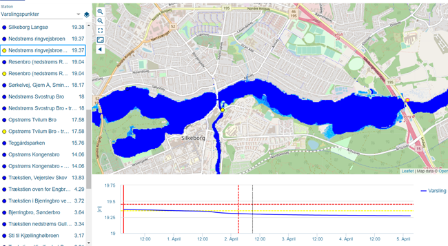
The online water level forecasting service was developed and tested, and the web pages were configured to show flood maps and highlight critical high water levels at locations along the river. The water level forecasts utilise real-time forecasts of sea water levels and rainfall. Due to the relatively long response time of river water levels caused by rainfall, runoff and rising sea water levels, it is possible to create three-day forecasts. The forecasts provide a common updated view of the entire river system and support timely coordination and action by authorities and citizens.
The web pages for dissemination of forecast information are expected to be made publicly available during 2020.